An Appalachian Trail Tale
Day 5: Friday, March 29th, 2013
Henry Gap to just past Wold Laurel Top = 11 miles
Miles to date: 35
Henry Gap to just past Wold Laurel Top = 11 miles
Miles to date: 35
A Mean Mien
Hiking the Appalachian Trail is a grave undertaking. Not the type of undertaking where undertakers take note, but grave nonetheless. When I think of walking two thousand plus miles, it overwhelms. Here’s a fun fact: the AT is longer than this year’s Tour de France.
But rather than view the trail as an endeavor that’s to be accomplished in one fell swoop, or one swell foop, I figure it’s best to think of it as a series of shorter hikes all joined together, one after the other. Stages, not unlike those in Le Tour de Dope.
Each stage may be a mountain stage, but each entails only a day’s amble, and that’s not altogether daunting. Every few stages, there’s a place where resupply and civilized rest is attainable. In essence, the AT is just a bunch of walking strung in back-to-back-to-back fashion, from one form of replenishment to the next. The end goal isn’t for the hiking to end, or to reach trail’s end, but to enjoy the means to that end, no matter how mean or meaningless those means may seem.
What else? The AT has a mean mien. It is NOT a side-winding snake; it knows no circumvolving.
To illustrate this point, I’ve already done more hiking on my toes than ever before. It’s not that I’m tip-toeing ala Alex the Unshod--just that the act is unavoidable because of the vertical gradient nearly all the climbs play host to. It is impossible to touch your heels to the ground when scaling yet another preposterously steep slope. (They’re preposterously steep, but dammit, they’re not over-the-top.)
The Appalachian Trail goes to great lengths to avoid going to great lengths; there are few switchbacks or hairpin turns; there is no beating around the bush(es). It’s straight up and straight down the most direct line possible, this much is straightforward.
With a backpack on, each upward step is an upheaval.
I can stand the climbs. (I’d rather stand on them.) What I loathe are the bruising descents. (The AT is hilly in either direction, like those barefooted walks to school through the snow when we were kids.) The feet, knees, hips and spine remind you of their presence every step downhill; in the event they forget to, other hikers will remind you how much theirs hurt, reminding you yours will. Plus, there’s farther to fall. Plus, it’s hard to generate warmth downhill. Point me upward and I shan’t complain. Much.
And here’s another consideration when heading downhill: the ATer still cannot touch his or her heels to the ground, since there’s often loose scree on the trail (where mud doesn’t drown it). At times it’s like walking on ball-bearings. One is forced to walk cat-like, with the toes landing almost simultaneously with the heels, or slipping is assured. Falls follow slips. Impact follows falls. Pain follows impact. And crying follows pain, at least in my case.
Here’s something to cry about: they say the vertical gain over the entire AT is comparable to climbing eighteen Mount Everests(1), from sea level to summit. The AT is not a level playing field. Had it been around during the dark ages, when nearly everyone presumed the world was flat, they’d have known better had they stepped foot on it. (The AT remains in the dark ages, what with all the trees.)
~~~~~~~~~~
Our day commenced when we had had enough of being tent-bound; cramped quarters overrode our concerns of the cold conditions outside. We had to pick our poison and even though it was still quite early, we’d had enough of the first form.
The first barrier was Blood Mountain, named for the hordes of hikers who take their lives at this point of the trail. (All it requires is a spork to the neck, so long as the utensil is metal and not plastic; I’ve been rehearsing.) In truth, no one knows why the ominous moniker(2), but the peak was as unforgiving as anything we’d scaled yet. At 4,458-feet, it is Georgia’s AT apex. And unlike most the mess behind us, we were rewarded with views. I was taken aback (but thankfully not taken a-back down the mountain) with the vastness of it all. Georgia is striking.
Striking too were our legs, so we made it a point to sit at the summit for a lengthy while. A stone shelter adorned the peak, as did quite a few needled trees, but we moseyed on just beyond, where a rocky outcropping provided a 360-degree diorama to everything below. It was hazy and even a bit cloudy, but only above.
After a hair-raising descent, we made our way to US Highway 19 at Neel Gap, the first resupply point on the trail. I was excited to see others, particularly a French-braided auburn-ish brunette who’d caught and passed us atop the bloody mountain. I’d come to learn her name was Kalamity, but there then I only wished I knew her. I could see that she was proof that not everyone who hikes the Appalachian Trail has a beard (though there’s still plenty of time for her to grow one).

The shop at Neel Gap, Mountain Crossings, catered to thru-hikers and only thru-hikers, that is unless motorists required freeze-dried foods or a new pair of hiking poles during their drive. Prices were unrealistic, expectedly so. Neel Gap is where many hikers realize:
The first barrier was Blood Mountain, named for the hordes of hikers who take their lives at this point of the trail. (All it requires is a spork to the neck, so long as the utensil is metal and not plastic; I’ve been rehearsing.) In truth, no one knows why the ominous moniker(2), but the peak was as unforgiving as anything we’d scaled yet. At 4,458-feet, it is Georgia’s AT apex. And unlike most the mess behind us, we were rewarded with views. I was taken aback (but thankfully not taken a-back down the mountain) with the vastness of it all. Georgia is striking.
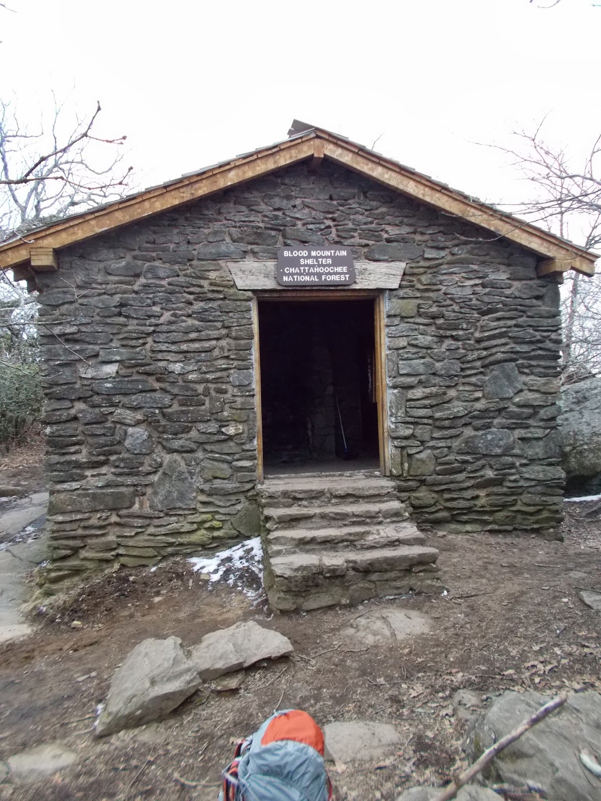 |
| The shelter atop Blood Mountain |
 |
| Ruth atop Blood Mountain |
The shop at Neel Gap, Mountain Crossings, catered to thru-hikers and only thru-hikers, that is unless motorists required freeze-dried foods or a new pair of hiking poles during their drive. Prices were unrealistic, expectedly so. Neel Gap is where many hikers realize:
A: A heavy pack cannot be taken lightly
B: What they’d hauled here was too much
3: Owning too much is never enough
Gone with the new and heavy, in with the new lighter-weight stuff.
Prepared accordingly, Ruth and I only needed a treat. We didn’t care about its weight, or, for that matter, its cost. Hunger trumps budgetary concerns.
We killed hours beside the store, chatting with others and ridding wrappers. While recharging our bodies we recharged our electronic garb. We were discovering just how social the AT is. Still, it amazed us how much alone time we’d found on the trail to this point, thirty two miles in. The AT is not overcrowded! Then again, the weather has sent a lot of backpackers packing; perhaps the numbers aren’t indicative of a normal year. One thing’s assured: the attrition rate will escalate--a good thing for those misanthropes too hard-headed to stop what they start. When all was charged we charged on, straight up Levelland Mountain. Level-land, my ass. Luckily, the trail remained sane the remainder of the day. No handrails required.
 |
| A storage shed at Neel Gap |
We’d end up tenting beside a bunch of log furniture. We were with Chris the Minnesotan, who waddles like an Emperor Penguin when he walks, and two others: Caboose, a ganja-toking gal from Los Angeles’s eastern most suburb (Denver), and a scraggly, happy-go-lucky kid named The Dogfather, from Toad Suck, Arkansas. I kid not: Toad Suck. He was hiking with his doghter (dä-ter; the g is silent), who called herself Bella (and who’s not silent). I tried flirting with the pup-tart--I pet all the dogs--but like females worldwide, she rejected my advances. The user-friendly pooch would guard us from bears throughout the night, what with her snoring.
(1) This is a two-part "foot"note...
Uno: if you have hiked the entire AT, you've hiked the entire AT; you've climbed approximately NO Mount Everests.
Ocho: even with today's fancy GPS units, there is no accurate way to measure elevation loss or gain and therefore no definitive answer to just how much climbing the the AT truly entails. This is because between measurements taken at each data-point there may be numerous ups and downs that are not captured. For instance, if you descend three hundred feet but regain it before the next data-point, the tally will display zero loss or gain. Think of it this way: if an ant were to thru-hike the AT he'd have to account for all the ups and downs that a human would simply step over. That "stepping over" is what the data-points do: they step over all unmeasured terrain between each one taken. This is the fractal nature of Nature.
"Fate"note 3: One of the saddest stories along the AT is that of twenty-four year-old Meredith Emerson. Emerson was murdered on Blood Mountain in ‘08. She and her dog were on a New Year’s Day hike when they came across the perpetrator, a drifter named Gary Hilton, who’d confess to the killing and ultimately be charged with three other such crimes in North Carolina and Florida.
 |
| The evening's digs |
 |
| Bella the backpacker |
Uno: if you have hiked the entire AT, you've hiked the entire AT; you've climbed approximately NO Mount Everests.
Ocho: even with today's fancy GPS units, there is no accurate way to measure elevation loss or gain and therefore no definitive answer to just how much climbing the the AT truly entails. This is because between measurements taken at each data-point there may be numerous ups and downs that are not captured. For instance, if you descend three hundred feet but regain it before the next data-point, the tally will display zero loss or gain. Think of it this way: if an ant were to thru-hike the AT he'd have to account for all the ups and downs that a human would simply step over. That "stepping over" is what the data-points do: they step over all unmeasured terrain between each one taken. This is the fractal nature of Nature.
"Fate"note 3: One of the saddest stories along the AT is that of twenty-four year-old Meredith Emerson. Emerson was murdered on Blood Mountain in ‘08. She and her dog were on a New Year’s Day hike when they came across the perpetrator, a drifter named Gary Hilton, who’d confess to the killing and ultimately be charged with three other such crimes in North Carolina and Florida.
 |
| Meredith Emerson |
No comments:
Post a Comment