An Appalachian Trail Tale
Day 37: Tuesday, April 30th, 2013
Lost Mountain Shelter to Old Orchard Shelter = 23 miles
Miles to date: 506
Day 37: Tuesday, April 30th, 2013
Lost Mountain Shelter to Old Orchard Shelter = 23 miles
Miles to date: 506
A Beautiful Day in the Neighborhood, Rogers That
Depending on whose hypothesis you believe, the Appalachians were once the loftiest mountain range on Earth. But no one was around to confirm it. No cartographers, geographers, geologists, land surveyors, or mountaineers. Even if they had been here, it’s debatable they’d’ve had the equipment needed to measure or scale them, not to mention the requisite porters or permits. (Plus, let’s face it: geologists would’ve been fully occupied, and justly compensated, extracting fossil fuels from the mountains.) Worse yet, they’d likely only have left us future generations with an unintelligible pictographical account of it all, engraved in crumbling rock (the Appalachians are both long-standing and fragile). But, despite the tangible paucity of proof, these rock-headed geologists have repeatedly proclaimed that yesteryear’s Appalachians would dwarf today’s Himalayas.
AT hikers are glad they do not.
I used to scoff at any mountains in the Lower 48 outside of the Rockies. They were hillocks in comparison--basement mountains, mole hills!--with the notable exceptions of Rainier, Whitney, Shasta, and a few others. Now I know better. Oh, what one learns with experience, that most trustworthy of travel guides.
The Appalachians are four hundred and eighty million years old. (When we say something is, ‘as old as the hills,’ we don’t mean these hills.) What this range lacks in stature, it more than makes up for in ruggedness and ridiculousness. (As I respond to ridiculing lady-loves: “But babes, it ain’t the size that matters! It’s the motion of the ocean!”) Eons of erosion have left these peaks looking docile from an aerial view, but the AT hiker knows that at ground level this isn’t so. Satellites lie. Airplanes lie. Cartographers lie. Cameras lie. Computers lie. Google Earth lies. Only the landscape tells the truth. That and the thru-hiker.
So trust me when I say today’s drudgery, like every other day, was just unjust. This, no matter how you divvy it. The layout leads knapsack-lugging lugheads up and over Virginia’s highest landform, Mount Rogers, via a series of steep, rocky drainages that trail-builders mistakenly labeled as the AT. Although it’s true I have yet to meet a hiker out here whom I hate--other than myself--I must make note of the hatred I hold for the trail-builders! May hell be as hard as the AT, you Satanic sonsabitches!
 |
| Unnecessary Roughness |
 |
| A dry Appalachian riverbed |
There’s a hypothesis ricocheting among thru-hikers that goes like this: official AT trail clubs--there are thirty one flavors of ‘em--vie with one another to make their particular stretch of the trail the toughest, most torturous, tortuous, steepest, most memorable, etc. Any superlative will do, so long as it outdoes either of the adjoining stretches of trail, if not every one. (It’d be no surprise to see white blazes painted on treetops or on the bottom of hot-air balloons.) The stretch I was moiling atop is maintained (a loose term, be assured) by the Mount Rogers Appalachian Trail Club. If its members never return to this area, it’ll still be too soon.
But no doubt the trail was well marked, as it’s been from the get-go. Blazes were here, there, and everywhere.
The Deutsch Dudes and the mature man were gone by the time I stirred. This was expected. What wasn’t expected was that I felt remarkable when waking--much better than I had yesterday. Maybe the stopover in Damascus did do me well. Although the going was tough, and although I was not, I managed. The scenery had a lot to do with it. In a (weird) word: frabjous.

There were wild ponies, wild flowers and a whole host of things gone wild. “Now THIS is why I hike!” I yelled wildly.
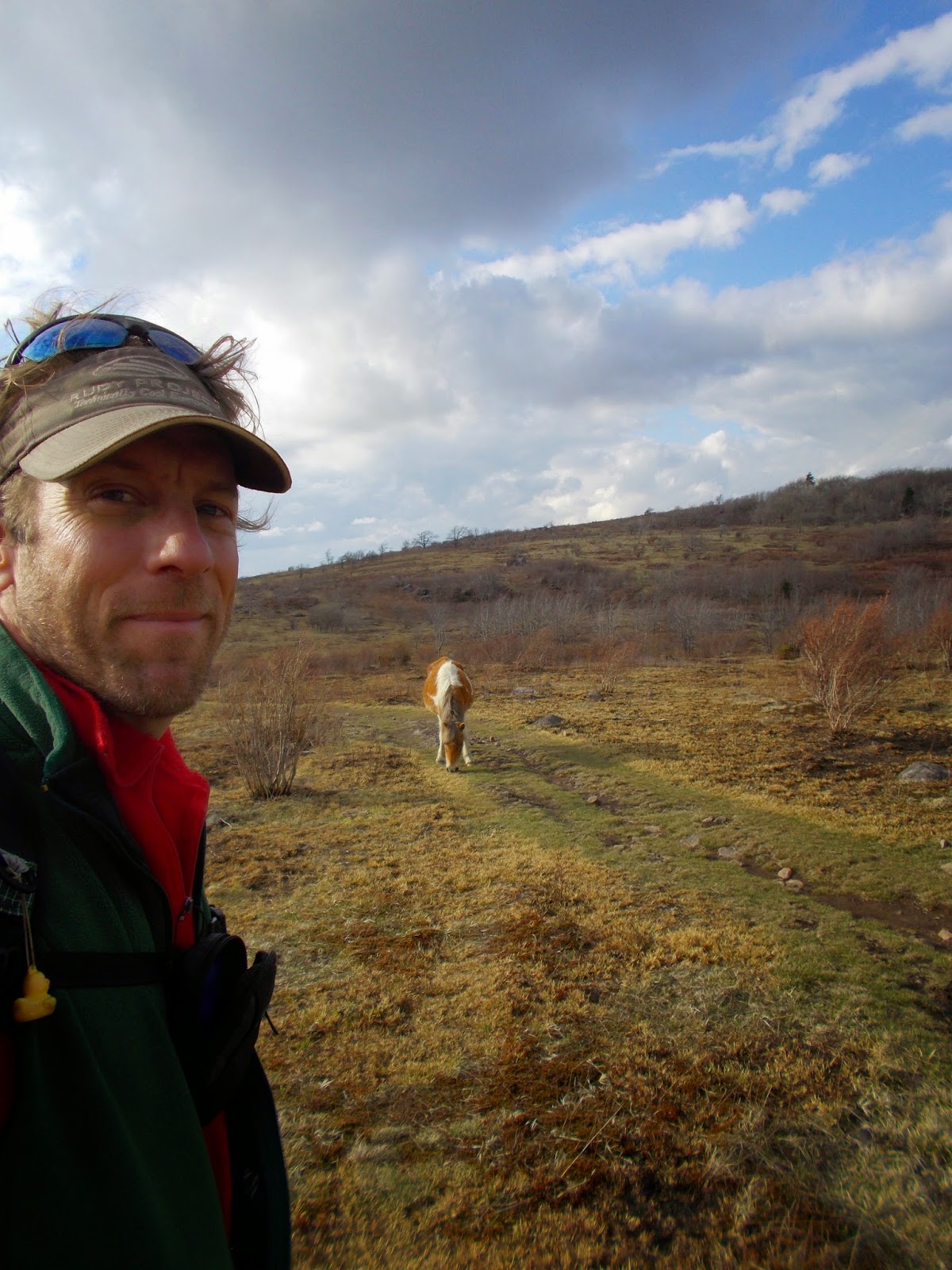 |
| Dig a pony |
Mount Rogers’ summit (5,729 feet) was tree-mendous--enveloped in breathing wood. Rich in oxygen, poor on views, not worth the side-trip. I expected nothing and was still disappointed. The peak had piqued my curiosity, so I took a peek. Unfortunately, all one sees are trees. But I had them to myself. I wished to commune, but they kept their thoughts to themselves. Large trees, small talk.
Virginia’s highest landmass (not a peak!) was named to honor Mister Rogers. William Barton Rogers was the tenth state’s first State Geologist. He was also the founder of the Massachusetts Institute of Technology, back when education technology included feathers and ink and ass-paddles. Ass-achusetts.

After the cloaked joke I sat my ass-achusetts down at the Thomas Knob Shelter and tried to enjoy lunch. Thomas Knob; an unfortunate name, but views were back in business. On the Appalachian Trail you have to take some good with all the bad. I chilled on the shelter’s off-kilter bench, taking it all in, getting the lay of the land. Not surprisingly, NOMAD had left his mark, as did a pair of lovers: ACE + EVE = TOGETHER FOREVER + 1 DAY. I sat there for two hours and not one hiker showed. This is atypical on the AT.
I’ve gone protracted periods without seeing anyone while hiking, but it takes just a brief break and others seem to appear suddenly. Burdened backpackers tend to plod at a parallel pace. So although you might not see anyone for long stretches, they may not be lurking far behind, or far ahead. Rests aren’t usually experienced alone, unless you bushwhack to your own private Idaho.
 |
| A constant companion near shelters |
Following the forgettable food--a bucket of dehydrated Idahoan mashed potatoes and medieval gruel with chia seeds; chunks of cheese; tuna; mangled M&Ms; and hand-picked dandelions for real flavor--I carried on toward the delicious Grayson Highlands. I hoped to catch a ride on one of the wild ponies, but the mangy mare wasn’t having it.
The horses remind me how I’d love to ride a long trail. Or at least walk alongside my four-legged friend, whilst she does the dirty work. I can cart niceties that way: collapsible chair, frying pan, pancake batter. Pipe dreams, here. The AT Green Pipe is reserved for two-legged beasts only, those not on anything (except drugs). No pack animals, no wheels. Just as well.
The horses remind me how I’d love to ride a long trail. Or at least walk alongside my four-legged friend, whilst she does the dirty work. I can cart niceties that way: collapsible chair, frying pan, pancake batter. Pipe dreams, here. The AT Green Pipe is reserved for two-legged beasts only, those not on anything (except drugs). No pack animals, no wheels. Just as well.

Leaving the Green Tunnel for Grayson Highlands felt like being freed from a clogged drain. Everything Mount Rogers lacked, the 4,800-acre park possessed, viz., far-reaching vistas, sweeping out in all directions. I’d deplete a set of camera batteries over the next few miles. I take terrible photos, but I take a lot of them. Back during the dark days of film, we couldn’t afford this luxury; we were limited to 24 or 36 abysmal pictures at a time. In the digital age, lousiness is limitless.
 |
| Spring is on its way! |
On the way to the AT’s 500-mile mark, at the Wise Shelter (where I was wise enough to know I didn’t belong), I waved to Mountain Goat and Tiny Klutz. The twenty-something New Hampshire pair were picnicking in a flowery clearing--sitting pretty, you might say--and I’d nearly passed by before sighting them. I’d toyed with the idea of joining their shindig, but was wise enough once more to acknowledge I’d be a third wheel. Again, wheels of any type are prohibited on the AT. They waved back, presumably pleased I didn’t roll back or backtrack.
At the automobile-accessible Massie Gap, I met a car-camping couple. (Now this is befuddling; wheels are allowed in some places along the AT!) After a small sum of small talk, Cedar Tree and Willow treated me to some lemonade and horribly inedible hot dogs. I’m no hot dog fan, never have been, but when it comes to calories of the no-cost variety, you take what you are given--tails, toenails, entrails, and all.
Cedar Tree runs a huge one-man company called ThePacka.com. He makes hooded parkas that fit over both backpack and backpacker, so rain doesn’t slither between back and pack, keeping both dry.
Cedar Tree runs a huge one-man company called ThePacka.com. He makes hooded parkas that fit over both backpack and backpacker, so rain doesn’t slither between back and pack, keeping both dry.
I’ve seen Packas; they make hikers look like hunchbacks. They’re sensible, but at >$100, no gracias. Still, with all the rain of late, I could use something a little more functional, something less unsightly, than the garb I use--garbage bags. I look like a walking yard sale on this train wreck of a trek.
 |
| A genial Cedar Tree, the man who keeps his own company |
Filled with nitrates, chicken peckers, lemonade and gratitude, I thanked the pair and returned to the antique hills. (When life gives you lemonade, it’s easier to be more appreciative of the lemons.) I ascended the 5,000-foot Pine Mountain as darkness descended, hurrying to reach the Old Orchard Shelter before it was too dark to see. One should know what he’s sleeping in and who he sleeps beside.
I’d make it just in time. There were four others staying. I recognized just one of them, a fur-child, but only because of the extra set of legs. I figured it best to slumber elsewhere, so as not to overwhelm the others with my odorous overtones. The pooch--named Go--had already made for my crotchular region one too many times. I worried for the safety of each of us. I walked on--Stay, Go!--and pitched shop nearby. I can foresee sleeping deeply tonight, the way only a satisfied individual can.

No comments:
Post a Comment